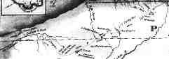
 excerpt from -- AN IMPROVED MAP of the Surveyed Part OF THE Territory OF MICHIGAN By John Farmer, 1830. 31k -- Gary, Ind., to Bertrand, Mich. 52k readable version
 Are you interested in a little more of the history behind Indiana Historic Road 20, the Chicago-Detroit Post Road?
Mr. Bailey [French fur trader Joseph Bailly] was monarch of all he surveyed up to 1831, when there was a mail line established from Ft. Dearborn to Detroit, called the Detroit and Chicago road. It ran through the territory that now comprises Jackson, West Chester [sic], and Portage townships. The mail was carried in knapsacks on the backs of two soldiers detailed for that purpose. In 1833 stage coaches ran over this line three times a week. The first contractors were Converse & Reeves. The Porter county Stage House was kept by Jesse Morgan. . . . The soldiers who participated in the Black Hawk War of 1832, marched over this stage route.
[page 16] In 1831, a road was cleared from Detroit to Fort Dearborn [Chicago]. It passed through what now constitutes Jackson, Westchester and Portage Townships. It was a wild, rude pathway, fatiguing in its roughness, abounding in dangers, and often uncertain in its course. Over this road a mail line was established between Detroit and Fort Dearborn, the mail being carried in knapsacks upon the backs of soldiers, two of whom were regularly detailed for this purpose.In 1832, the entire Northwest was thrown into great consternation by the tidings of outrage and massacre committed by Black Hawk in the regions near the Mississippi. . . . Government troops were immediately dispatched to the scene of war, and passed over the Detroit and Fort Dearborn road. . . . The year 1833 was an important era in our history. A stage line was established, and coaches ran from Chicago to Detroit, making three trips per week. The first contractors of this line were Messrs. Converse & Reeves.
[page 156] Up to 1833, Western travel kept to the beach of the lake [Lake Michigan], fording the mouths of the streams. In 1831, a mail route was established from Detroit to Fort Dearborn. This ran through Jackson, Westchester and Portage, or rather through what now constitutes those townships. The mail was carried in knapsacks upon the backs of two soldiers until 1833, when stage coaches began to run over this line tri-weekly. Converse & Reeves were the first contractors on this route Jesse Morgan settled on this route on Section 6, and kept the Porter County Stage House. In 1832, the soldiers going to and from the Black Hawk war passed over this route.
[page 215] These two are the only taverns that have ever been kept in the [Portage] township. These were on the old stage line between Detroit and Chicago. This formerly ran along the beach of the lake, but was afterwards moved farther south. To enable the stages to cross the Calumet [for the new southern route], a bridge sixty-four rods long was built in 1836 and 1837.
[page 416] The only post-route extending across the [Lake] county, prior to 1836, was the Detroit & Fort Dearborn mail, which had been located many years before, the coaches first ran along Lake Michigan beach, but later through Liverpool, on Deep River, and finally, on the Bradley route.
[page 62] The road surveyed between Detroit and Fort Dearborn was merely a verification of the old Indian trail across the Southern Lake region. Landmarks were established, a few bridges, strongly built of unhewn timbers, were thrown across some streams, a few hillsides were graded, and little else was done or needed. The trail was established upon ground naturally firm and solid. It avoided quagmires and other obstacles, and as the only vehicle to pass over it was the mail wagon--a sort of buckboard, guiltless of springs, drawn by Indian ponies--which came one week and returned the next, no deep wheel ruts marked the still unbroken sod. All travel was in the saddle, and the solitary horseman always received hospitality at the [Bailly] Homestead, where this trail crossed the large front lawn.[page 91] A proof of this seclusiveness, which Indiana knew how to respect, is a measure which Grandfather [Joseph Bailly] took regarding the mail route, which at first was taken over the old Indian trail, crossing the long lawn in front of the residence. At first the tiny rill of travel was a source of entertainment and pleasant social intercourse. Later on the increasing stream became a nuisance, and when it was at length necessary to define the road more decidedly by means of road improvements, Grandfather petitioned the proper authorities to turn the road away from his premises, averring that it was a disagreeable intrusion upon the privacy of his home life.
This petition was granted, and the road turning in a westerly direction after crossing the river, led the traveling public to the shelter of a simple hostelry, built at Grandfather's expense and managed by his tenants. This inn was almost three-quarters of a mile northwest of the homestead residence, and a mile and a half south of Lake Michigan, which was reached by crossing the marsh and the sand hills over the old Indian trail, which the mail route rejoined shortly after leaving the tavern.
[page 21] In 1833 two events occurred which set the stage for the entrance of the pioneers into the southern part of the county. The first was the completion through the region of the Fort Dearborn-Detroit Trail, the second, the opening of a government land office at LaPorte in an adjoining county.[page 71] In 1820 the Federal Government obtained, by treaty with the Indians, the right to construct a road through the area. In 1824, $10,000 was appropriated, and the survey started in 1826. Surveyors wanted to straighten and shorten the route, but soon discovered the Indians had been wise in going around the marshes and had found the shallowest places for fording streams. The route decided upon followed the Indian trail.
When the new road was finally completed in 1833, travelers found it slow and hazardous; they often were forced to leave their coaches or wagons outside Michigan City and continue on horseback. There were great stretches of black mud in Michigan and deep beds of sand along the lake shore. One writer said so many vehicles had been abandoned along the road that it resembled the path of a retreating army. Fords were dangerous. One of the most difficult of these was at the [former] mouth of the [Grand] Calumet River, where travelers unfamiliar with the approaches to a large sandbar frequently got into trouble. [That is now dry land around the Marquette Park bathhouse in Gary.] A route farther from the lake shore, through Baileytown, became popular; this course later was to become a part of the Dunes Highway.
Return to top of page. Return to my main highways page.
[page 55] Many travelers and settlers came by way of the Great Lakes to Detroit, whence they chose the less hazardous route overland to Niles, La Porte, and Michigan City. From there they followed the Lake Michigan beach to Chicago. Later a branch of the road reached the beach by way of the Bailly trading post.40 This became known as the Chicago-Detroit Road, and in winter when ice prevented navigation on the upper reaches of the Great Lakes, traffic on this route was particularly heavy. Lieut. James Strode Swearingen led his troops over this route in 1803 to establish Fort Dearborn,41 and in 1816 other soldiers came along the beach to rebuild the fort which had been destroyed by the Indians during the massacre there in 1812. In the early years mail and dispatches were brought this way by soldiers to the military and civilian population of Fort Dearborn. The United States was granted by treaty with the Indians in 1821 the right to use the road and in 1825 it became a post road.The first important stage on the road between Detroit and Chicago was established in 1833. Begun as a weekly stage from Niles to Chicago, it developed rapidly with the increase of immigration and travel in the succeeding years until 1835 when one stage ran each day between the two centers. The various stage interests on the Detroit-Chicago Road combined to form the Western Stage Company and in the summer of 1839 its stages left Chicago daily for the East.
[page 58] With the coming of the settlers, the beach road was abandoned in favor of easier routes to the south. The character of these roads, and even the direction they took, varied with changing weather conditions and also by the degree of settlements along the way. The roads that came through Michigan City or La Porte converged in the vicinity of the Bailly homestead, and from there several branches could be taken to Illinois and to Chicago.
40Charles J. Latrobe, The Rambler in North America, MDCCCXXXII-MDCCCXXXIII (2 vols. London, 1835), 2:185.
41See the "Journal of James Strode Swearingen," in Quaife, Chicago and the Old Northwest, 376.
Those of you readers who are not from this area and thus cannot easily picture what you are reading about, take heart from the fact that you now know more than most newspaper or commemorativ e booklet writers, let alone the average northwestern Indiana citizen. Perhaps much of the erroneous written material about the Post Road is due to most of the road not existing anymore and to so many different routes having been followed to Chicago over the years and even at the same time. As I am a strong believer in the need to individually debunk each historical misstatement about this Ft. Dearborn-Detroit Road, even though they are repetitive, I may eventually stick exerpts from many of the minor publications up here.
About a decade ago, I envisioned putting together a little map book showing where the platted 1825 Detroit-Chicago Road ran on maps of today. As I had even less prospect of breaking even on that publishing project than on my other books (none of which I have finished yet, if you're curious), I dropped that notion. I guess I could now put something like that up here on the Web for next to nothing (as I already have most of the base maps). Look for that to appear around the time we're colonizing Pluto.
The Plat of the United States Road from Detroit to Chicago, as surveyed and marked by James McClosky, Jonah Baldwin, and Laureat Durocher, C'om.s, copied by John Farmer, 1825, was printed on several sheets and distributed by the federal government. Maybe I'll add them here one of these days, though it will take a lot of MBs to allow the small annotations to be readable. For now, here's my scan of a photostatic copy of a map from the National Archives. I am including only the Indiana portion of the map, which ignored Lake County entirely. Note that the same guy drew it as drew the official plat.
AN IMPROVED MAP of the Surveyed Part OF THE Territory OF MICHIGAN By John Farmer, 1830. 31k -- Gary, Ind., to Bertrand, Mich. 52k readable version
A little joke on me: As the plat shows an "Old Fortification" next to the road east of (where) Door Village (was settled in 1830), I figured that was the stockade built by settlers during the Black Hawk War scare. Once I realized that the fort wasn't erected until 1832, I figured that the map engraver added it to the surveyors' original data for the printed map. Of course that doesn't explain the "old" appellation. More significantly, the same feature is on the 1830 Michigan map. In other words, that must have been an old Indian mound, which I was unfamiliar with. Oops.
![[WEBMASTER E-MAIL]](../../~Ogden_Dunes/letter.gif) | roads |
|
|---|
This page is at http://member.tripod.com/IanHistor/maps/ihr20.html.